Thu 13 Mar 2014: Counter-mapping in the Community – Talk at BAR Gallery

Counter-mapping in the Community

Thursday 13th March, 6.30pm
BAR Gallery, 4-5 Queens Parade, Walm Lane NW2 5HT

Join us at BAR Gallery for a presentation of the Latymer Mapping Project in the context of counter-mapping and community art projects. We will present our research, methodology and processes and share our experiences of running a community-focused project in North Kensington, as well as reflecting on the response from local residents to the final map.
This is a great opportunity to discuss in depth the various issues surrounding community engagement and participation, the artist’s role and responsibilities in the process of urban regeneration and useful strategies for working with local residents, organisations and community representatives.
For further information please visit BAR Gallery’s website.

Photos from our July Counter Cartography Tours!

We had a great time running our counter cartography tours for InTRANSIT Festival this last week. We have walked with a mixture of people very new to the area and those who have lived here for a long time, making for an interesting group learning experience, picking up some new facts about the area as well as informing and updating each other on new bits of news.

Our route covered only a very small area starting at Latimer Road tube station, weaving through the Lancaster West Estate up to the former site of squatting community Frestonia, onto the nicknamed “Monsoon Village” and then North up Freston Road via the Silchester West estate and finishing up under the Westway elevated roundabout. Even on this fairly small circuit it proved difficult to squeeze in the vast rich histories (and futures) of the area and we found ourselves careering off on various tangents..shame we couldn’t spend all day on the walk!

Thanks to everyone who came along and endured the hot weather, it was a great experience for us and we hope you all continue to enjoy the map.

Thanks again to the RBKC InTRANSIT Fund for making this possible!

Here are some photos from the walks:

Wednesday-1

Saturday-Walk-2

Wednesday-2

Saturday-Walk-1

Saturday-Walk-3

Saturday-Walk-4

Saturday-Walk-5

Saturday-Walk-8

Wednesday-3

Wednesday-4

Saturday-Walk-6

Wednesday-5

Wednesday-7

Wednesday-6

Saturday-Walk-7

Wed-paper-1

Wed-paper-2

Wed-paper-3

Wed-paper-4

Wed-paper-5

Wed-paper-6

Wed-paper-7

The Latymer Map is Launched!

The Latymer Map was launched on Saturday 20th July at the Dalgarno Community Centre. Thank you to everyone who came along, it was a brilliant evening, interesting passionate discussion and great to see both familiar and new faces!

The map is now out there and you can pick up your free copy from the following places:

Dalgarno Centre, 1 Webb Close, London W10 5QB

North Kensington Library, 108 Ladbroke Grove, London W11 1PZ

The Tabernacle, 35 Powis Square, London W11 2AY

Portobello Road Market Offices, 72 Tavistock Road, London W11 1AN

Keep in touch by subscribing to this blog and to the group+work mailing list (info[at]group-work.org) and send us your feedback of the map and your experience of using it in the area!

Map Launch 1

Map Launch 2

Map-Launch-3-for-web

Map-Launch-4-for-web

Counter Cartography Tours at InTRANSIT Festival this July!

Radical-Histories-Walk---Graffiti-Wall

Are you interested to learn more about the way North Kensington is changing and the various issues that have shaped its history? Do you want to get more involved in your community?

The Latymer Mapping Project will be running two guided tours in the Notting Barns ward of North Kensington this July, as part of RBKC’s open air festival InTRANSIT. Armed with our maps, we will explore issues and stories in the area relating to regeneration, housing, social issues, and a selection of cultural facts and personal anecdotes.

Contact info[at]group-work.org to book a place on one of the dates:

Saturday 20th July, 2pm
Wednesday 24th July, 2pm

The Counter Cartography Tours will finish at a local cafe where visitors can join us for a cup of tea and continue our discussions.


InTRANSIT Festival

InTRANSIT was first launched in 2007 when the programme took the form of artist-led walking tours around the borough. The Festival has since evolved to work with emerging and established artists from Britain and abroad to bring the streets and outdoor spaces of Kensington and Chelsea alive for a week each summer.

For further information about InTRANSIT and to view the programme click here.

The Latymer Map is Ready for Take-off!

Map-Launch-Image-for-Mapping-Blog


After a year of research in the North Kensington area and a series of workshops with the local community, the moment has now arrived to share the Latymer Map!

Join us for drinks and an open discussion with the contributors of the map on:
Saturday 20 July, 6pm at The Dalgarno Community Centre, 1 Webb Close W10 5QB

Doors are open from 6pm and the discussion will start at approximately 6.30.

RSVP on our Facebook event page here.


The Latymer Triangle, by Dee Harding

Filmmaker Dee Harding has made a brilliant short film called ‘Latymer Triangle’ which focuses on the research practice of fellow artist Constantine Gras, whose research in the last year has been engaged with the immediate area surrounding the Silchester West estate close by to Latimer Road Tube Station and the infamous Westway flyover.

Latymer Projects has worked with both Dee and Constantine as part of our opening exhibition ‘Common Ground’ in January 2012 and it is great to see them working together on this film!

Watch the film here!

A return visit…

Recently we returned to the Silchester Estate and the surrounding local area to see what changes have occurred since we were asked to vacate the Latymer Projects space in September 2012, and to continue to add information to our upcoming map of the area (see our previous post for more info on that!)

Armed with a camera, some thick clothing and our mapping workshop notes we spent 2 hours visiting some of the sites that were discussed in those sessions almost a year ago. We made our way from the Silchester Estate, heading South to visit the “Monsoon Village” of clean glassy facades and walkways lined with CCTV cameras, around the Frestonia housing co-op and Bramley Road, back up North-East through the 1970s brutalist architecture of Lancaster West Estate and Grenfell Tower, overlooking the new North Kensington Leisure Centre and Academy developments, and finishing our walk along the underside of the infamous Westway. Read on for some of our observations.

23-Feb-Walk-Image-Block-1 600px


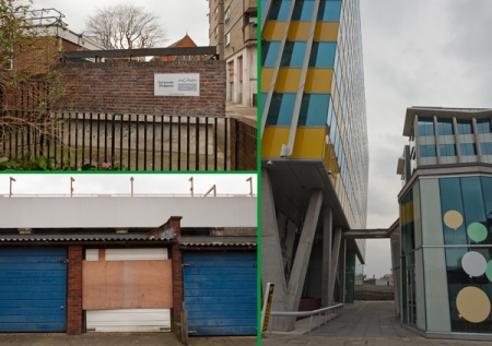
The former Latymer Family Centre where Latymer Projects was housed remains as we left it. The garages, marked up as being the first to fall for construction, were also left untouched. This came as no surprise to us, but our sense of disappointment was palpable: to think of the progress we made in that short time, and to imagine the possibilities had we been able to continue using the space between September 2012 and now.

Looking on the RBKC web pages for the Silchester redevelopment plans, there doesn’t seem to be any indication that plans are behind schedule – demolition is noted as due in March 2013 and residents were recently invited to meet the contractors Mace on 13th February. It’s strange to think that during our time at the space, rumours abounded that the demolition of the centre and the garages could begin as early as March 2012 – indeed, that is supposed to be why the lease on the family centre had a 6 month break clause, and we could be asked to vacate with just a few weeks notice. This continual uncertainty of whether the centre would be demolished made our time at the space, along with the studio artists’ tenancies, very precarious. However, we imagine that this sense of disappointment is felt far more acutely for those residents that have been disrupted for the redevelopment.

We decided to walk through the Lancaster West Estate, which, like many estates of its kind built in the 1970s, are large enclosures with various walkways connecting separate block-like sections. The Heygate Estate in Elephant & Castle is perhaps the most notorious structure of this type in London; one of the starkest examples of post-war urban decay, the Heygate is now being demolished to make way for the developer-led gentrification of the area, following long and embittered battles between tenants, activists and the local council (see Southwark Notes to follow this). Initially intended as a functional and low-cost solution for the construction of government buildings and social housing in the aftermath of World War II, Brutalism as a style is characterised by repetitive angular geometries, an honesty towards materials and a rough, blocky appearance. As an architectural philosophy, the movement is closely associated with socialist utopian ideology; for the architects and planners, these estates were human-oriented, socially progressive visions of the city, which sought to serve its citizens and foster a sense of community and civic responsibility. Critiques of the movement are numerous, not least because of failure of that vision and the association of “the estate” with crime and social deprivation. In most cases, these projects have also been subject to neglect and decay, which should also be attributed to lack of care and withdrawal of funding by local government and management authorities, and not the sole result of anti-social or irresponsible behaviour on the part of a small number of tenants.

The Lancaster estate itself was visually impressive, and the walkways even echo the Westway flyover itself. While the estate did not seem dangerous or deprived, neither did it have a particularly social atmosphere, but perhaps that can be blamed on the cold weather! There was certainly some gestures towards communal living, in the form of benches, some sizeable grassy areas and large planters. We walked back on ourselves and took a route around the estate heading towards the Grenfell Tower block, which looks over the construction site of the upcoming academy and leisure centre.

23-Feb-Walk-Image-Block-2 600px

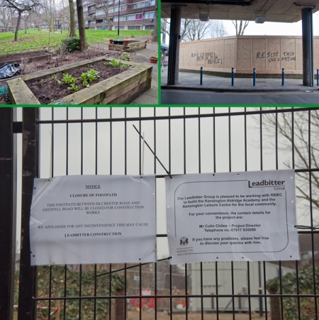
Kensington Leisure Centre’s last day of business was 24th December 2012, and the new leisure centre and academy are scheduled to open in September 2014. Whilst the council states that the rebuild will improve facilities, make better use of space and energy, and provide urgently need school places, residents of the area are sceptical. There has been a lot of protest over the plans, in part due to the obvious disruptions over the next year and the lack of investment in the current community. Following residents’ feedback, the council has now earmarked £6 million towards improving the estate. For info on local action and community resources in opposition to the development, check out the Grenfell Action Group: http://grenfellactiongroup.wordpress.com. For more information about the development plans: http://www.rbkc.gov.uk/newsroom/capitalprojects/newleisurecentre.aspx

23-Feb-Walk-Image-Block-3 600px

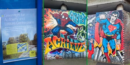
Pictured above is a wall mural by Grenfell Tower, featuring a cast of colourful characters and aspirational slogans. If anyone has further information on this mural, please get in touch: we’re very interested to know who commissioned this, who the artists were, and if any schools or local residents were involved. We’d also like to know your opinions on the mural: do you think it improves or detracts from the landscape?

We now know a little more about the mural thanks to some local knowledge – the mural was promoted by the Lancaster West Estate Management Board as a regenerative project for local children to get involved with. Young people from the Rugby Portobello Project created the mural though sadly only one actually lived on the Estate itself, with the others coming from other parts of North Kensington. 

The mural is based on principles that the Rugby Portobello Project are said to observe such as respect for one another, to look out for your peers, not to bully, etc. Some residents really like it, others loathe it. Apparently there were plans to do another mural opposite this one but this hasn’t come to anything as yet, owing to the Kensington Academy and Leisure Centre project. The mural was opened by the then Mayor of the borough, Cllr. Tim Coleridge and Cllr. Judith Blakeman. We would still like to hear your thoughts about it!

Do you find the messages hopeful or patronising? Do you think this work reflects the interests and opinions of local residents, or does it just represent other people’s ideas about community? Do you think the works of artists in the area improves relations and brings the community together, or do you feel these commissions try to make up for shortcomings in public provision elsewhere?

23-Feb-Walk-Image-Block-4 600px

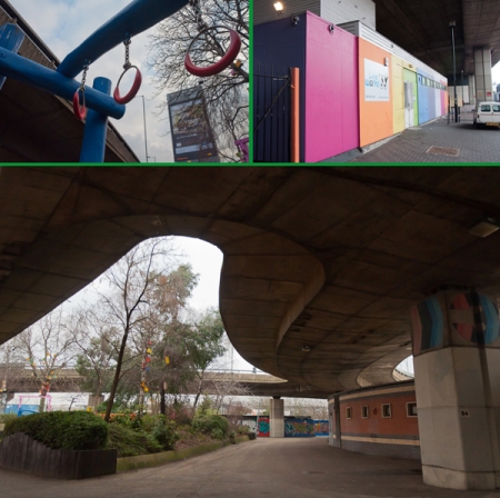
Walking along the underside of the Westway, we wondered about the future of the spaces beneath the flyover. The Westway Development Trust recently put out a call to local people, community groups and businesses to make proposals for these spaces, with the intention of turning the underside of the Westway into a community hub. The proposed development would be a mixture of community-focused spaces and private-sector designated units. Our hopes are that the successful proposals will be responsive and sensitive to local needs. We’ll be heading over to see the Westway Development Trust’s exhibition of plans at 6 Thorpe Close, London W10 5XL, where you can leave your feedback and responses to proposed plans.

Exhibition details can be found here: http://www.westwayregeneration.org/exhibition-at-6-thorpe-close, and for further information on the Westway Regeneration plans visit: http://www.westwayregeneration.org

Production of the final map and a proposal to RBKC’s InTRANSIT Festival!

Following our six mapping sessions with local residents, artists and researchers at Latymer Projects in Spring 2012, we continued to talk to residents and have been collecting further research and information, inspired by the various points that came up in each session. We are now in the stages of producing a final map for the Notting Barns area, which we hope to launch in late Spring/early Summer.

Latymer Projects and co-producer Constantine Gras are also hoping to put the map in action at InTRANSIT Festival which takes place in the borough during July 2013 and features a variety of temporary and site-specific cultural and social events engaging with our urban environments and experiences of living in the borough. Our proposal has just been sent, listen out for further details!

For further info about InTRANSIT Festival: http://www.rbkc.gov.uk/subsites/intransit.aspx

Below: a sneak peek at one of our design samples…

Sneak-peek-map-sample

Session 6: Digital and Open Source Mapping

We were joined this week by artist Sandra Crisp who screened her recent video ‘Mapping London’s Subterranean Rivers’, a digital 3D map elevation that reveals the city’s unseen underground and ancient waterways. The group took some time with Sandra to generate our immediate responses to the video, and Sandra also explained her process of analysing her research and data and finding a way to manifest that visually.

Sandra’s video can be viewed online here.

We then went on to look at various examples of online mapping projects, discussing the kinds of virtual communities that grow around these user-generated data hubs, whether that be people sharing personal memory maps on flickr or the intricately woven politically and socially driven maps and tools created by TheyRule.net and debategraph.org, which encourage co-operative and collaborative user participation on a highly global level. Debategraph.org aims to offer a “powerful way for communities to learn about, think through and decide upon complex issues […] by enabling communities of any size to externalise, visualise, question, and evaluate all of the considerations that any member thinks may be relevant to the topic at hand – and by facilitating intelligent, constructive dialogue within the community around these issues.” We have set up our own debategraph on the website under the title ‘(London) Riots’ working directly from the notes we compiled last week around perceptions of the riots in London (see post on Session 5). Sign up with debategraph for free and join our community if you would like to view or add to this graph.

While debategraph.org encourages the development of communities around particular questions and issues, TheyRule has a more overtly political agenda; TheyRule is concerned with mapping some of the relationship of the US ruling class, taking as its focus, the boards of some of the most powerful US companies, showing how many of these boards share the same directors. Some of these individuals sit on up to 7 of the top 1000 companies! It has a very intricate search system allowing you as a user to browse through these interlocking directories and even add your own research if you create a log in to the site. TheyRule is a fantastic example of how mapping can be used as a powerful critical research tool.

We returned to many of the questions raised in our first session surrounding map-making itself and counter-mapping – the power inherent in the process of map-making, selection, filtering; who has access to data and how is it distributed; making visible and repressing information. In this context we made a simple comparison between Google Maps and OpenStreetMap (http://wiki.openstreetmap.org/wiki/Google_Map_Maker), the former owned by a gigantic global entity with the power to claim ownership (and profit) over any raw data input by the global community; and the latter an open source tool that allows its users to freely input, reuse, modify and distribute its data, allowing users to inform and improve the system.

We finished the session by spending some time together thinking over the research we have gathered so far over the last 6 weeks and plotting some of these points on an online map…..

Session 5: Radical Histories

Introduction

This session was framed around 3 pivotal and radical events in recent history: 1958 Race Riots, community activism related to the building of the Westway and the Frestonia Free state (1977). They all occurred in North Kensington, specifically within a half mile radius of Latymer Projects. We attempted to map social conflict and community activism, questioning how we understand and interpret history. Our discussions also looked at the relevance of these events for today.

1958 Race Riot

ITN News film, 5 September, 1958: article.php?story=2005100819205024

After viewing the news clips from 1958, we discussed the causes / impacts of the riots. One of our participants recalled how as a young man he was caught up in the hysteria and prejudice against the black community that had recently settled in Notting Hill. Although there is a well documented trigger incident for the 4 days of rioting (an argument between a Swedish woman and her black husband outside Latimer Road station), there were other background factors in play: post-war housing shortage, slum housing in North Kensington and right-wing elements.

A mapping exercise explored the links / differences between the 1958 and 2011 riots.

1966-1970 Westway and Community Activism

Pathe News: Highway in the sky: http://www.britishpathe.com/video/highway-in-the-sky/query/Avenue

BBC Education Zone, film: Motorways in central London, how public protest stopped construction: http://bbc.in/spfN5y

Although in the planning pipe-line since the 1930s. there was limited community resistance to the Westway being built. Most residents would probably not have been aware of the Western Avenue Extension (as it was then called) until it was about to be built. In the late 1960s, the community focus was more on securing future play and community space under the motorway. Activism became more pronounced in 1970s when the residents of Walmer Road / Acklam Road, whose houses were sited very close to the superstructure, demanded to be rehoused. There was a protest that held up the official opening of the Westway.

1977 Frestonia

BBC iplayer, From Frestonia to Belgravia: The History of Squatting:  http://www.bbc.co.uk/programmes/b017cfv4

Tony Sleep’s photography website: http://tonysleep.co.uk/

Squatters began to occupy houses in the Latimer Road / Freston Road area in 1972. In 1977 they had formed the Republic of Frestonia and declared independence from the UK.

We listened to an audio recording and slideshow of photographs taken by Tony Sleep. He was a resident of Frestonia at the time and acknowledged how the local working class community regarded them as middle class hippies. This was confirmed by a participant in the session who recalled looking down on the Frestonia crowd. Listening to the audio and seeing Tony’s photos for the first time, he revised his former opinion and acknowledged sympathy.

We also had a discussion around how a community group could define itself as indepenent from wider society. The Frestonian’s, for example, produced their own passports, stamps and had their own newspaper and ministers of state.

The perception of “squatters” was also referenced, especially in relation to recent legislation that is attempting to criminalise squatting: http://www.squashcampaign.org/

Radical history walk

Here is a map of the walk that we made and includes photos taken at the site of the 1958 Race Riot, Frestonia and elevated section of the Westway.

http://www.everytrail.com/view_trip.php?trip_id=1529337